Best Backpacking Loops in North Carolina
by Sean B ·
This page may contain affiliate links. For more information, see our "About Us" page.
Best Backpacking Loops in North Carolina

North Carolina is home to the Great Smoky Mountains National Park and nearly 96 miles of the famed Appalachian Trail. While these both deserve the praise they are given, North Carolina has some of the best backpacking loops, day hikes, and even overnight treks that are lesser known. A great way to experience the outdoors is with a loop hike, where you start and end in the same place. No need for shuttles, and you won’t see the same scenery keeping your outing fresh and exciting.
Here we will focus on five loop hikes – these can be done as day hikes, or with most you can make it an overnight getaway. The hikes range from just under a mile, to nearly 17 miles round trip. The hikes we’ve chosen fall into the “moderate” category, of course it depends somewhat on your skill and endurance level. You’ll definitely get a good workout on all but the shortest hike listed, but there are no extreme climbs or technical expertise required. Just bring the 10 essentials with you and you’ll be fine.
#1 - Forney Creek Loop
This is a stunning, yet challenging, loop hike that begins at the Clingman’s Dome parking lot, located in the Great Smoky Mountains National Park. If you plan to spend camp, you will need a permit from the NPS.
The trail begins by descending along the Forney Ridge trail towards Andrew’s Dome, a grassy, open ridge where you’ll enjoy incredible views. Keep going, and at the 4.5 mile mark you’ll join the Springhouse Branch trail. There you’ll continue until you reach the Forney Creek Trail at Camp 71. You can choose to spend the night here, but it’s worth pushing forward to Camp 70, located where Forney and Jonas Trails meet, and the site of a stone chimney, which was part of a home for loggers over 100 years ago.
The return back to the trailhead is on the Forney Creek Trail, a mostly-uphill journey that is marked by passing a couple of picturesque waterfalls.
One thing to prepare for with this hike is the creek crossings – there are seven or more crossings where you’ll likely get your feet wet. This will depend on recent rainfall, but be prepared to take off your shoes, or even better, wear quick-drying trail shoes.
Note: This loop can be extended by returning on the Jonas Creek Trail, which joins the Welch Ridge Trail, and then finally on the Appalachian Trail back to the trailhead.
Total Loop Distance: 16.8 miles

#2 - Graveyard Fields Loop Trail
This one is kind of a modified loop – basically the loop is in the middle, so there is a little out-and-back at the beginning and end, especially if you do the recommended hike at the end to the Upper Falls. You’ll begin at the Looking Glass Overlook and follow the Mountains to Sea Trail, passing by Skinny Dip Falls as you gain elevation. In another mile or so you’ll reach a junction, where you’ll take a right and continue on the Mountains to Sea Trail (this is the start of the loop). After a mile you’ll reach the turnoff for the Graveyard Ridge trail – take a left and you’ll head south on the Graveyard Ridge Connector trail.
Around half a mile later, you’ll reach another junction – this is for the Graveyard Fields Loop – you’ll take a right here. After 1/3 of a mile you’ll reach the Upper Falls Trail – this is a worthwhile out-and-back that is 0.8 miles each way. Upon reaching the falls you’ll want to allow time to soak in the view – it’s also a great spot to have lunch and rest up a bit for the return hike.
The return is a little more straight-forward, and completes the loop. You’ll start by returning to the Upper Falls/Graveyard Fields Loop Trail (take a right). At just under a mile you’ll cross the Yellowstone Prong and reach a junction, where you’ll take a right. Soon you’ll come across a very short detour to Second Falls – may as well take the time to check this out as well. After that you’ll continue on, reaching the Mountains to Sea Trail again for the return back to the trailhead.
Unfortunately camping isn’t allowed, so this is recommended for someone looking to do a fairly challenging day hike.
Total Loop Distance: 10.7 miles
#3 - Shining Rock Wilderness Loop via Art Loeb Trail
This is a moderately challenging trail that can be done in a day, but there is also camping available to make it an overnighter. It comes highly recommended if you enjoy wildflowers and views – mountain vistas as well as waterfalls. If you do camp, bring a bear canister, as there are regular bear sightings and they aren’t afraid to grab unattended food.
Pick a clear day to do this one – the views along the Art Loeb Trail are amazing – take in the surrounding mountains, including the dramatic final destination of this hike – Shining Rock. This peak rises from the forest below, made of beautiful white quartz. Overall this trail is highly recommended for the views and the challenge of the hike, but it’s a good idea to bring good maps or a GPS app with you, and be prepared for some bushwhacking as there are a few sections that are lightly-maintained.
If you do camp there are spots near Shining Creek and Grassy Cove Top – both are great for an overnighter, however, both can be busy and as mentioned before, they are often frequented by bears.
Total Loop Distance: 9.7 miles

#4 - Sam Knob Loop
While this one can be done as a 2.5 mile out and back, it’s recommended to extend it a bit by making it a loop hike. From the Black Balsam Road trailhead you’ll get the legs warmed up over 2/3 of a mile as you head west towards Sam Knob (stop at the waterfall for a quick rest if needed). There are several sections of boarded walkway, likely put in place to protect the meadows. You’ll reach a junction, where you will take a right to ascend to Sam Knob (elevation 6050 ft). Watch your footing as you go up – the trail has been eroded in places, so loose gravel or slick mud can cause a fall if you’re not too careful. Once you reach the summit, spend some time and take in the views, which are expansive from here (on a clear day).
When you’re ready to head back, you’ll go back the way you came back to the junction, where at this point you’ll take a right. Enjoy the slightly-downhill walk through the forest before crossing Flat Laurel Creek a couple of times (both crossings can usually be done without having to take off your shoes, unless there have been heavy rains recently). Soon after you’ll meet up with the Flat Laurel Creek Trail, which is an old railroad grade, at which point you’ll take a left. Head east for 1.5 miles, enjoying a brisk walk with very little elevation gain/loss, before reaching the trailhead to complete the loop.
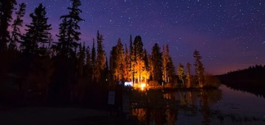
This is a great hike for a quick overnighter as well – you can hike about halfway, near the summit approach, and find a great spot to set up your tent. As this area is pretty far away from towns, it’s perfect for stargazing on a clear night.
Total Loop Distance: 3.2 miles
#5 - Flat Rock Loop Trail
This is by far the shortest hike in our list, but we wanted to include one that features beautiful views and scenery, but was also appropriate for all ages, and appropriate for dogs as well (on leash). There’s only about 140 feet of elevation gain, so this one also works well for folks with weak knees. No need for fancy hiking gear either, just bring some water and perhaps sunscreen and you’ll be set.
Located along the Blue Ridge Parkway, this short trail includes a wide variety of plant-life, including azaleas, blueberry bushes and rhododendron. There are views of the Linville Valley for miles, and ample spots to stop, enjoy lunch and enjoy some peace and solitude. There are other worthy hikes along the Blue Ridge Parkway, but if you’re looking for the perfect combination of scenery, well-maintained trail, and minimal time spent, this one is an outstanding choice.
No camping allowed on this one, which makes sense given it’s short length and relatively high popularity. Either way, this wouldn’t be a comprehensive list of the best backpacking loops in North Carolina without this beauty.
Total Loop Distance: 0.7 miles
Best Backpacking Loops in North Carolina - Conclusion
So there you have it – a list of the best backpacking loops in North Carolina, with everything from short hikes that you can do with kids and a dog, all the way to longer hikes that will test your endurance. This list really just scratches the surface though, and I’ve just focused on the western part of the state here – there are just so many great hikes to choose from. Hopefully this shows that there’s more to North Carolina hiking and backpacking than the Appalachian Trail or merely focusing on the opportunities in Great Smoky National Park. If you’re looking for more hikes on the east coast, consider our article “Best Shenandoah National Park Backpacking Loops“. Alternatively, if you’re wanting to head a bit more west, check out “Top 3 Backpacking Loops in Olympic National Park“. Happy travels!